Quaternary reef growth history, sea-level and environmental changes
Purpose: reconstruct the depositional history of fossil Quaternary reef sequences and associated sea-level and environmental changes based on field observations and core-based studies of fossil reef limestones
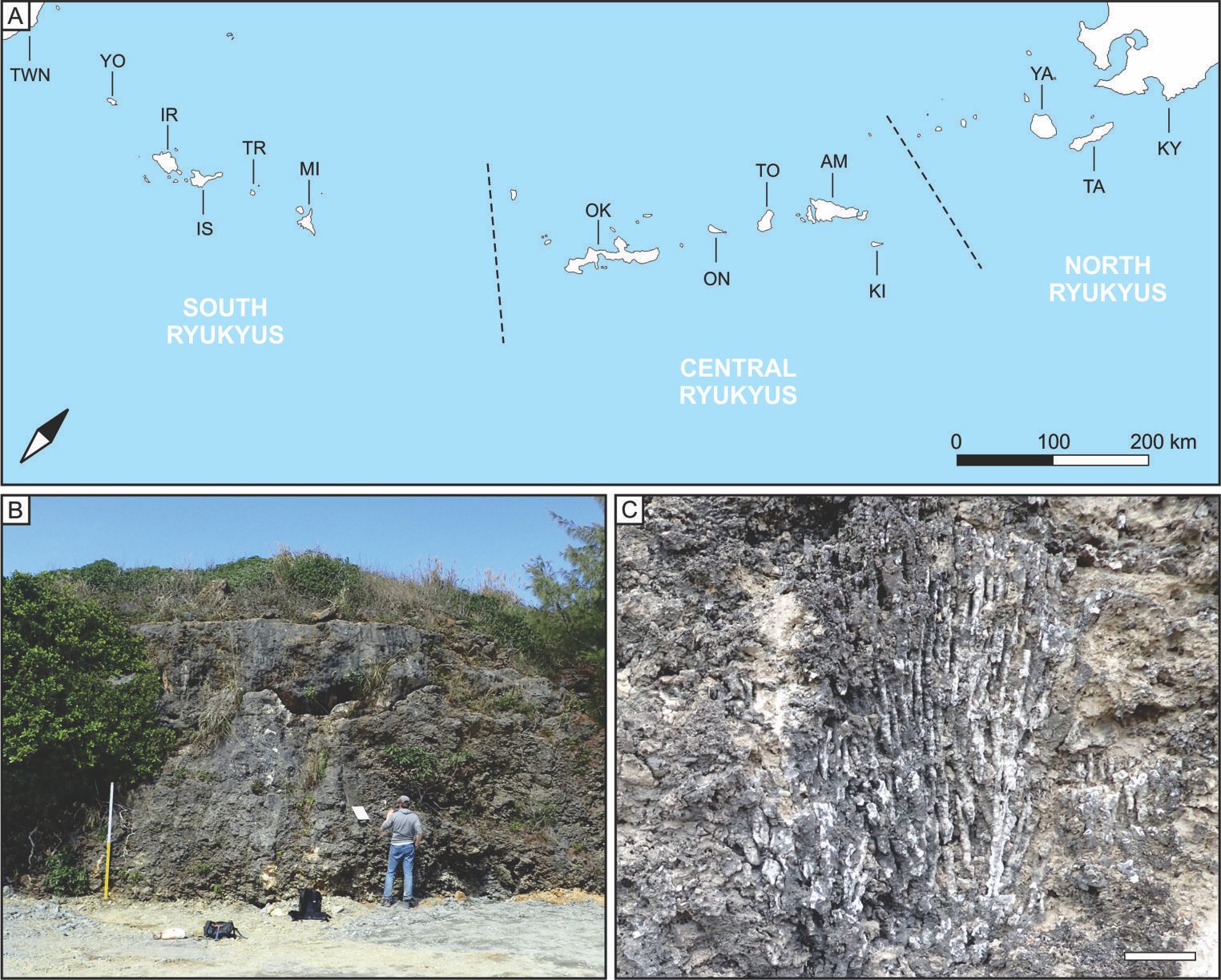
Ryukyu Islands
The Ryukyu Islands, located between Kyushu and Taiwan, are the southernmost islands of the Japanese archipelago. They are composed of tens of islands and islets, the largest being Okinawa. The Ryukyu islands are fringed by coral reefs, the highest-latitude reefs in the northern hemisphere. Reef growth in the Ryukyu islands is thought to have initiated 1.5 million years ago. Pleistocene fossil reef deposits are extensively distributed in this region due to tectonic forces which have raised fossil reef limestones above sea level. Uplifted reef limestones are therefore readily accessible for sedimentological and paleontological studies, providing a unique window on the long-term history of reef development and paleoenvironmental changes at high latitudes. One example is the late middle Pleistocene coral-rich limestones of the Minatogawa Formation. Research is being carried out to reconstruct the depositional history of these limestones and constrain the age of the Minatogawa Formation.
Collaborators*: Yasufumi Iryu (Tohoku University), Kazuhiko Fujita (University of the Ryukyus), Yusuke Yokoyama (University of Tokyo)
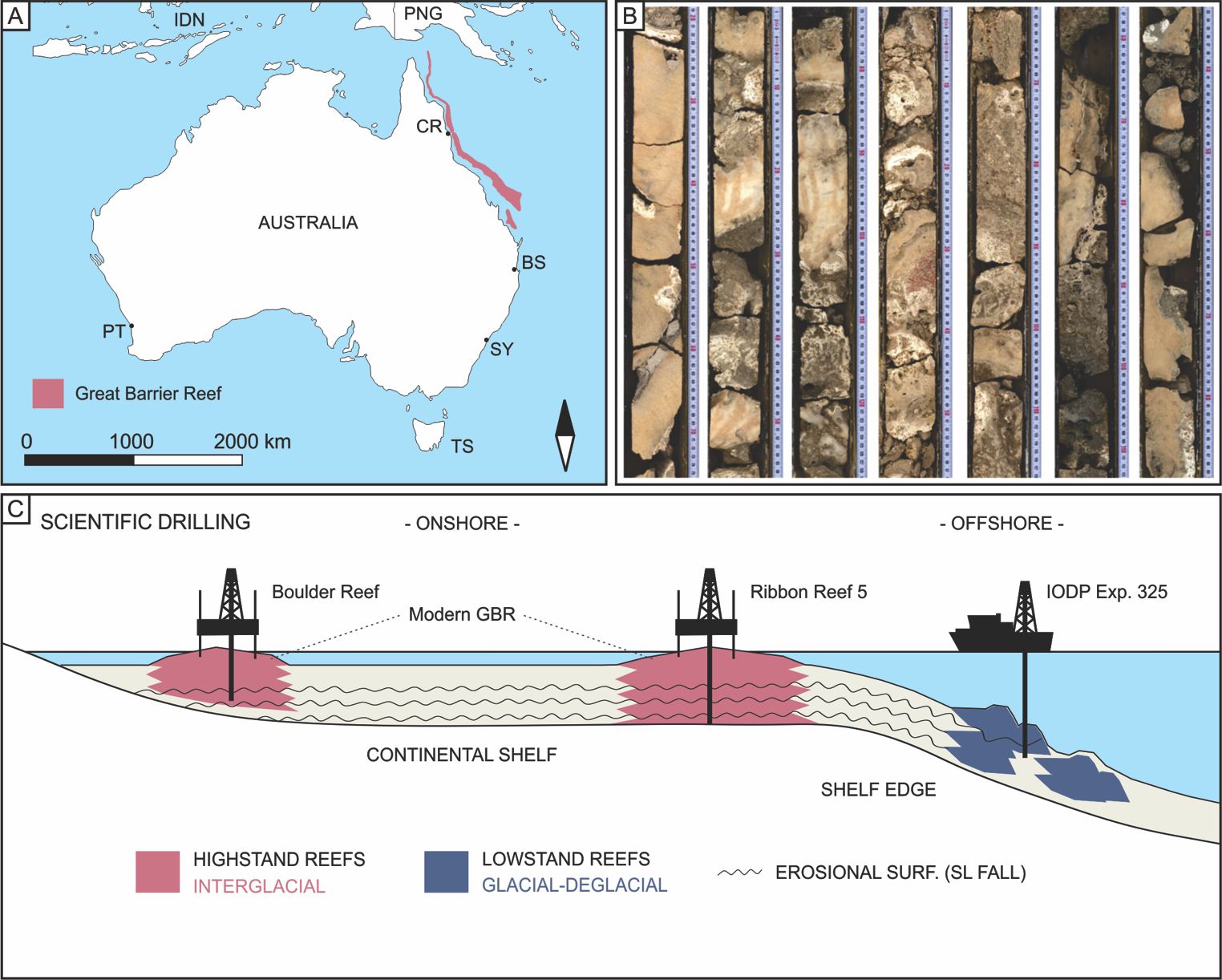
Great Barrier Reef of Australia
The Great Barrier Reef in eastern Australia (GBR) is the largest reef ecosystem in the World. Unlike the Ryukyu islands, it is a tectonically stable area. Drilling is therefore needed to reach fossil reef limestones formed when sea level was lower than today. It is also a so-called far-field site
, i.e., an area far away from former ice-sheets characterized by limited vertical crustal motion in response to ice loading and unloading during glacial-interglacial cycles, and makes it a valuable site for sea-level reconstruction. During warm periods and associated sea-level highstands, reefs developed on the eastern Australian shelf where the modern Great Barrier Reef is now present. Up until recently, there was no direct evidence of reef development in eastern Australia during past ice ages when sea level was much lower than today. The International Ocean Discovery Program (IODP) Expedition 325 changed that by drilling into reef-like structures at various depths along the shelf edge and uncovering coral- rich reef sequences dated to the last ice age and subsequent deglaciation. The combination of onshore and offshore core studies in the GBR province are contributing to unravel the history of the world's largest reef ecosystem and to gain unprecedented insight into past climate and sea-level changes.
Collaborators*: Jody Webster (University of Sydney), Juan-Carlos Braga (University of Granada), Yasufumi Iryu (Tohoku University), Yusuke Yokoyama (University of Tokyo), Don Potts (University of California, Santa Cruz)
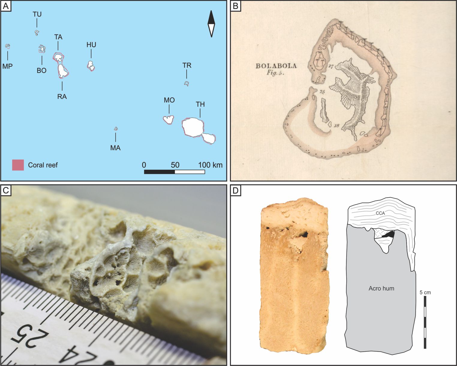
Bora Bora, French Polynesia
Bora Bora is part of the Society islands archipelago in French Polynesia. It is composed of an extinct volcano encircled by a barrier reef separated from the volcanic edifice by a lagoon. Illustrations of Bora Bora is shown in Charles Darwin's (1842) book The Structure and Distribution of Coral Reef Islands
(see page 3 and Plate 1) as an example of a barrier reef. Based on observations at Bora Bora and other islands during his 5-year, round-the-world travel on the HMS Beagle, Darwin devised his model of reef development, explaining the genesis of fringing, barrier and atoll reefs, which he relates to the progressive subsidence of a volcanic edifice surrounded by a reef system aggrading to remain close to sea level. In addition to a prominent barrier reef, Bora Bora also displays fringing reefs attached to the shores of the volcanic edifice. Cores drilled along leeward and windward transects at both fringing- and barrier-reef sites are analyzed to study the relationship between reef development and factors such as sea-level changes, subsidence and antecedent topography.
Collaborators*: Eberhard Gischler (Goethe University Frankfurt), Juan Carlos Braga (University of Granada), Gilbert Camoin (CEREGE)
Seychelles Islands
The Seychelles archipelago consists of more than 100 islands and is located north of Madagascar. It is a tectonically stable area and a far-field site like the GBR. The Seychelles islands are part of a microcontinent which, together with Madagascar and India, started to drift away from Africa 200-150 million years ago. The famous granitic outcrops of Mahe, Praslin, La Digue and other nearby islands are remnants of that continental crust; these islands are collectively referred to as the granitic Seychelles. There are two other types of islands in the Seychelles: the low-lying coral islands and the high limestone islands. The low-lying coral islands are mainly composed of carbonate sand and coarser bioclastic sediments. The high limestone islands (Aldabra, Assumption, Cosmoledo, Astove) are formed of fossil reef limestones rising up to 8-9 m above sea-level. These limestones have been dated to the last interglacial period (LIG). Limestone outcrops of LIG age are also found in the granitic Seychelles but t hey are limited to relatively small, i.e., few meters in width and height, lumps of limestone attached to granitic boulders. The LIG climate was warmer and sea level higher than present which make the LIG a potential analogue for future climate and sea-level. The Seychelles Islands are therefore an ideal place to study the reef response to warming and sea-level rise and for accurate LIG sea-level reconstruction.
Collaborators*: Gilbert Camoin (CEREGE), Nadine Hallmann (CEREGE), Claude Vella (CEREGE), Alessio Rovere (MARUM), Juan Carlos Braga (University of Granada), Stephan Jory (IFREMER), Gwenael Jouet (IFREMER)
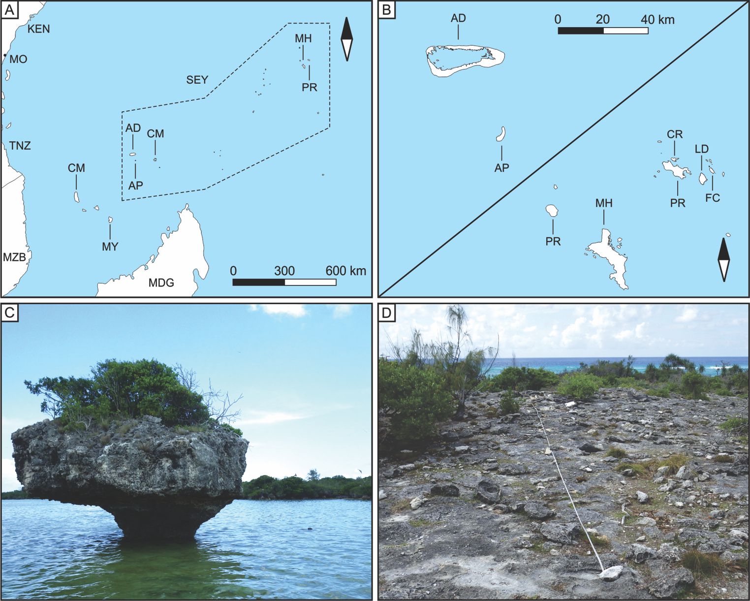
Champignon
in the lagoon of Aldabra. D. Transect set on fossil reef limestone at Aldabra. AD. Aldabra, AP. Assumption, CM. Cosmoledo, CR. Curieuse, FC. Felicite KEN. Kenya, LD. La Digue, MDG. Madagascar, MH. Mahe, MO. Mombasa, MZB. Mozambique, SEY. Seychelles islands, TNZ. Tanzania. Photo credit: M. Humblet.
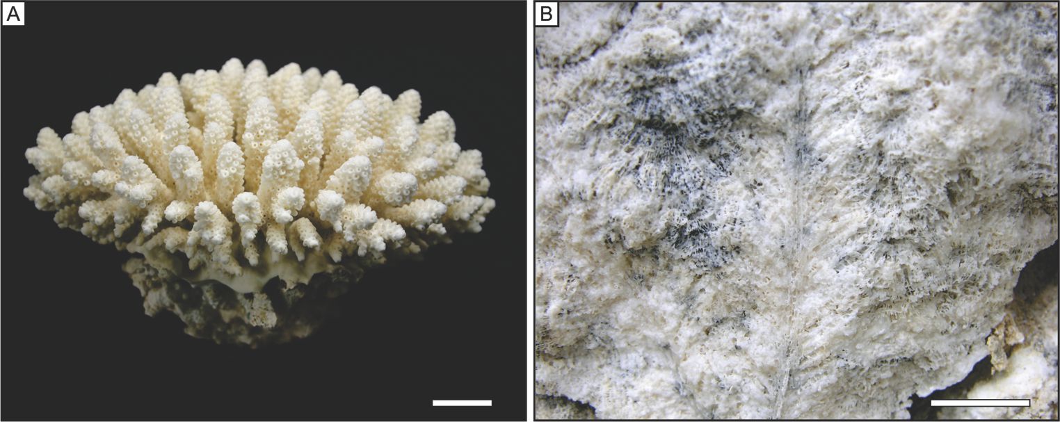
Taxonomy of fossil scleractinian corals
Purpose: define useful macroscopic morphological criteria for the taxonomic identification of fossil reef corals in the field
Modern reef coral taxonomy is largely based on the external morphological characteristics of coral skeletons. However, the surface of fossil corals exposed in outcrops or in drilled cores is often obscured by encrusters or sediments, or altered by bioerosion or physical abrasion, which make their identification very difficult. For geologists studying fossil reefs it is therefore important to establish identification criteria visible in cross sections that are useful to identify fossil corals in the field.
Collaborators*: Jody Webster (University of Sydney), Chuki Hongo (University of the Ryukyus)
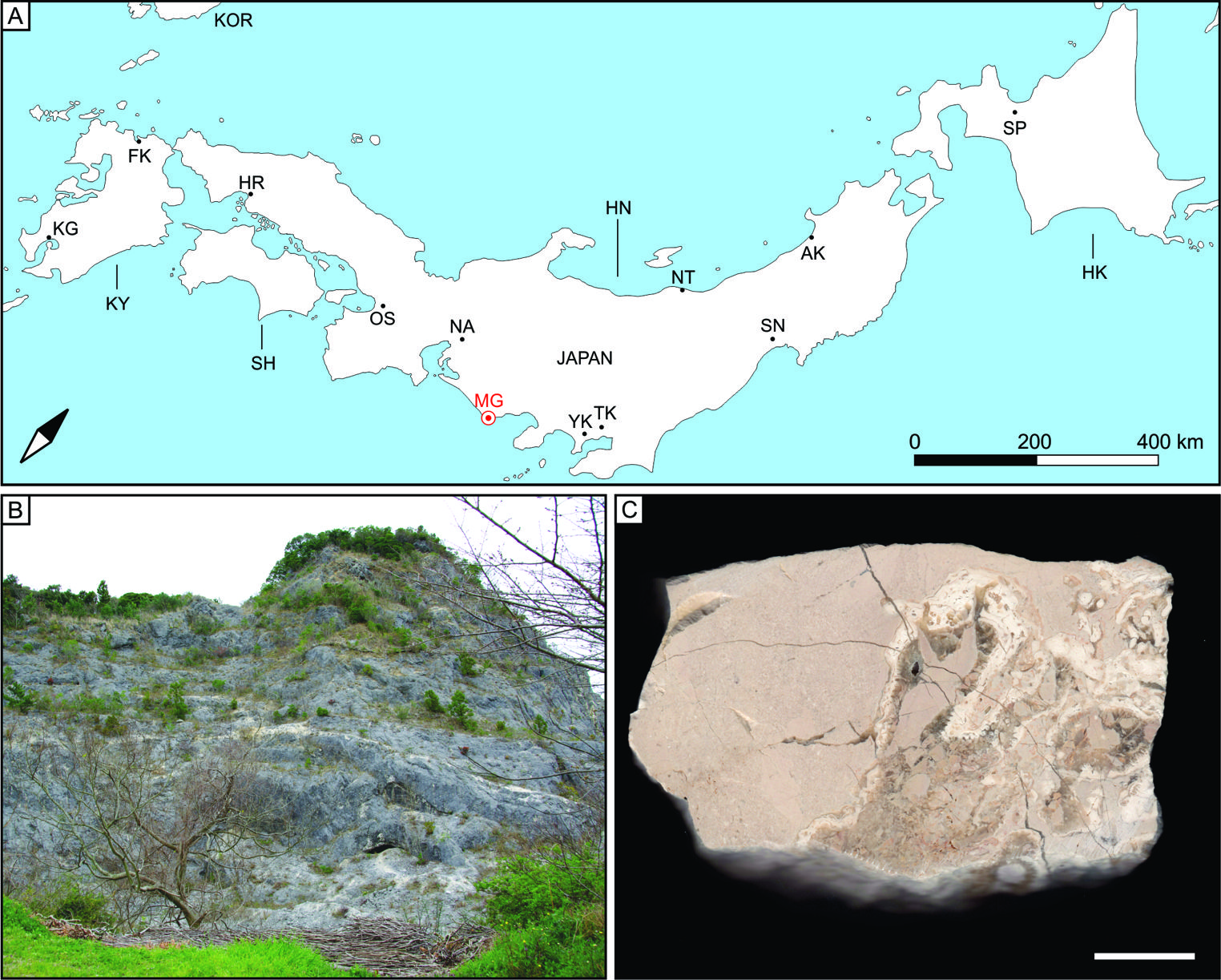
Miocene corals of central Japan
Purpose: Biogeography of reef-building corals and paleoenvironmental analyses of fossil coral assemblages of Miocene age from Japan
Modern coral reefs in Japan are mostly restricted to the Ryukyu islands, but non-reefal, marginal coral communities extend to 35° N (near Tokyo). Coral species richness is correlated with sea-surface temperature and decreases from south to north, from over 350 species in the South Ryukyus to less than 25 near the limit of their latitudinal distribution (Veron, 1992). Global climate during the Miocene (23-5 million years ago) was warmer than today and showed a maximum warming around the mid-Miocene (Mid-Miocene Climatic Optimum). Coral limestones of Miocene age from Japan yield important information on the impact of global climate change on coral species distribution and reef growth.
Collaborator*: Yasufumi Iryu (Tohoku University)
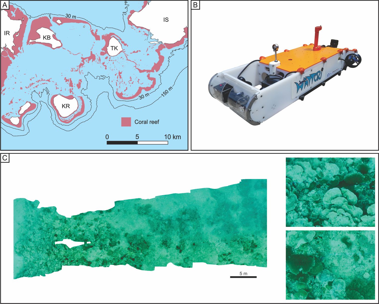
Modern biota, sediments and seafloor morphology at mesophotic depth in the Ryukyus
Purpose: ROV- and AUV-based imaging of the seafloor and study of the distribution and composition of biota and sediments at mesophotic depth around the Sekisei Lagoon, Yaeyama islands, South Ryukyus
The discovery over the past 20 years of very extensive mesophotic (30-150 m) coral ecosystems has drawn considerable attention on the ecological importance of these ecosystems in coral reef regions (e.g., genetic connectivity between shallow and deep coral communities). In addition, submerged fossil reefs formed when sea level was lower than today have been found at mesophotic depths in the Atlantic, Indian, and Pacific oceans. As archives of past climate and sea-level changes, these drowned fossil reefs are prime research targets for geologists. Despite their importance in biology and geology, mesophotic habitats in coral reef regions are still largely unexplored. The goal of this research is to use remotely operated vehicles (ROVs) and autonomous underwater vehicles (AUVs) to explore the mesophotic seafloor in the region with the highest coral diversity in Japan, i.e., the Sekisei Lagoon, located in the Yaeyama islands, South Ryukyus. In particular, we are using an AUV that this is being developed at th e University of Tokyo (Prof. Toshihiro Maki's lab) with the special purpose of surveying coral reef ecosystems, including the mesophotic reef habitats, as well as the ecological transition to non-light dependent communities. The Highly Agile Terrain Tracker for Ocean Investigation (HATTORI) is a lightweight robotic submersible which performs continuous video imaging of the seafloor while maintaining a constant altitude along a predetermined path.
Collaborators*: Toshihiro Maki (University of Tokyo), Yasuo Furushima (JAMSTEC), Takashi Sakamaki (University of Tokyo), Frederic Sinniger (University of the Ryukyus)
* note that the lists of collaborators are not exhaustive
References
Darwin, C., 1842. The Structure and Distribution of Coral Reef Islands. London, Smith, Elder and Co., 65, Cornhill.
Veron, J.E.N., 1992. Hermatypic Corals of Japan. Monograph series volume 9, Australian Institute of Marine Science.
Marc Humblet, Department of Earth and Planetary Sciences, Nagoya University